Brantford, Ontario, Canada, Summer 1992
I embarrassed myself.
West of Hamilton and surrounded for the most part by farmland, Brantford is known for several things:

It lays claim to the invention of the telephone, the birthplace of “The Great One” hockey player Wayne Gretzky, entertainer Phil Hartman, Group of Seven painter Lawren Harris, and a Mohawk village.
Lawren Harris (1885 – 1970)

Phil Hartman (1948 – 1998), performing as Bill Clinton on Saturday Night Live
During my walking days exploring Canada I dutifully tried to visit as many cultural attractions as I could.
Alexander Graham Bell conceived the first telephone here on 26 July 1874.

Alexander Graham Bell (1847 – 1922)
His first North American home, the Bell Homestead National Historic Site, has been painstakingly restored to its original condition.

The Brantford Sports Hall of Recognition inside the Gretzy Centre has memorablia from dozens of local track, football, lacrosse and wrestling stars, but the main attraction is, of course, the permanent display for Wayne Gretzy.
It was here in this quiet town that Gretzy honed his game on the backyard hockey rink at his childhood home before shattering the NHL record books and blitzing his way to four Stanley Cups.

Wayne Gretzy´s first pair of ice skates, age 3
But in 1992 these attractions did not draw my attention.
Southwest of town, the Six Nations territory has been a First Nations centre for centuries.
Captain Joseph Thayendanegea Brant led the Six Nations people (Mohawk, Oneida, Onondaga, Cayuga, Seneca and Tuscarora) here from New York State in 1784 and established a village that has long served the district´s First Nations tribes.

Joseph Brant (Thayendanega)(1743-1807)
I visited the sites that celebrate their legacy:
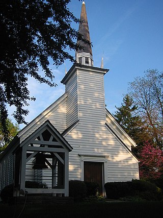
Her Majesty´s Chapel of the Mohawks, three km from the centre of town, is the oldest Protestant Church in Ontario (1785) and the world´s only Royal Indian Chapel and the site of Captain Brant´s tomb.

The Woodland Cultural Centre serves as an indigenous performance space, an art gallery and a cultural museum, with exhibits following a timeline from prehistoric times through to contemporary native art.
The Chiefswood National Historic Site, across the street from the visitor centre, was the home of Mohawk poet Pauline Johnson, whose best-selling Flint and Feather poetry is truly a moving blend of European and aborginal cultures.

Pauline Johnson (1861 – 1913)
The Six Nations of the Grand River Territory and the aborginal community of Ohsweken offers a glimpse of native life past and present and their Confederacy Band Council House remains a unifying cultural and political association which has helped settle disputes between bands and proudly represents and preserves First Nations heritage.
And it was here that I embarrassed myself.
I had arrived at a delicate time in aborginal – white relations in Canada.
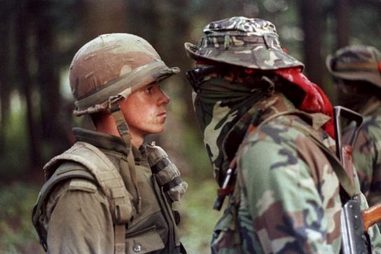
The Oka Crisis of 1990 was still a sour memory and the seeds for the Grand River Land Dispute (2006) had just been planted.
The Oka Crisis was the first well-publicised violent conflict between First Nations and the Canadian government in modern times.

The Crisis developed from a local dispute between the town of Oka and the Mohawk community of Kanesatake, both just outside the metropolis of Montréal.
The town of Oka was developing plans to expand a golf course and residential development onto land that had been traditionally used by the Mohawk, including pineland and a burial ground marked by standing tombstones of their ancestors.
The town of Oka and its Mayor Jean Ouellete did not consult the Mohawk on the plans and no environmental or historic preservation review was taken.
Opponents of the plans found the Mayor´s office unwilling to discuss them.
So the Mohawks erected a barricade blocking access to the area.
Ouellete demanded compliance with the court order, but the protesters refused.
Ouellete asked the Sureté du Québec (SQ), Québec´s provincial police force, to intervene.
The SQ responded to the barricade by deploying tear gas and flash bang grenades.
Gunfire between both sides began.
After a 15-minute gun battle, SQ Corporal Marcel Lemay was killed and the police retreated.
The Mohawks seized six vehicles – four police cars and two front end loaders – and barricaded the main highway.
Natives from across Canada and the United States joined in and all roads that passed through Mohawk territory were blocked, including the Mercier Bridge, a major access point between the island of Montréal and the heavily populated South Shore of the St. Lawrence River.
Frustration over traffic congestion and the blocked roads led to residents of Chateauguay to burn an effigy of a Mohawk warrior while chanting “sauvages“.
The SQ having lost control of the situation were replaced by the Royal Canadian Mounted Police (RCMP) who proved equally ineffective and finally the Canadian military got involved.
The Oka Crisis lasted 78 days and the golf course was cancelled, but the issue of indigenous rights was far from resolved.
In 1992 Henco Industries purchased 40 hectares of land, the Douglas Creek Estates, from the Canadian government, which the Six Nations had never agreed to sell to Canada.
The Mohawks, after trying legal action to no avail, finally took action in 2006 in a manner similar to the Oka Crisis.
The Grand River land dispute at Caledonia, near Brantford, was held from 2006 to 2014.

Grand River land dispute, Potluck for Peace, 15 October 2006
I was asked by the Museum to write my opinion regarding aborginal rights, in the hopes I could understand their plight.
I responded to this request by writing that I was not responsible for what injustices my forefathers had done.
I committed the same error that many others have:
I treated the First Nations as if it were they and not us that had taken over the land.
It has taken decades of travel and experience to appreciate how much of a racist bigoted idiot I was to write those words and I wish that I could go back in time and give my younger self a swift kick in the ass for my ignorance and stupidity.
We, the white man, have not only over generations robbed our indigenous people of the most basic rights of physical survival and integrity, but as well have tried to destroy the preservation of their lands, languages, religions, heritage that are part of their existence as a people.
And we violate them by creating laws that ensure our rights over theirs.
And this cultural desecration has been going on for centuries against original peoples, whether it is Australian aborgines, New Zealand Maori, Canadian First Nations, American natives, Japanese Ainu…
The list is long…
Indigenous peoples and their interests are represented in the United Nations primarily through the mechanism of the Working Group in Indigenous Populations (UN-WGIP).

In April 2000 the United Nations Commission on Human Rights adopted a resolution to establish the United Nations Permanent Forum on Indigenous Issues (UN-PFII) as an advisory body to the Economic and Social Council with a mandate to review indigenous issues.
In September 2007, after a process of preparation, discussions and negotiations stretching back to 1982, the General Assembly adopted the Declaration of the Rights of Indigenous Peoples.
The non-binding Declaration outlines the individual and collective rights of indigenous peoples, as well as their rights to identity, culture, language, employment, health, education and other nations.
Of the 192 member countries of the United Nations, 11 nations abstained, 34 did not vote, the remaining 143 nations voted for the Declaration.
Standing Rock Indian Reservation, North/South Dakota, USA, 2016

Standing Rock is a Hunkpapa Lakota and Yanktonai Dakota native reservation straddling the North and South Dakotas boundary.
The 6th largest reservation in the United States, Standing Rock has a land area of 9,251 sq. km / 3, 571 sq. miles with a population of 8,500.
The Standing Rock Sioux Tribe is part of the Great Sioux Nation.
In 1868 the lands of the Great Sioux Nation were reduced in the Fort Laramie Treaty to the east side of the Missouri River and the state line of South Dakota in the west.
The Black Hills were considered by the Sioux to be sacred land and were located in the centre of territory awarded to the tribe.
In direct violation of the Treaty, General George Custer and his 7th Cavalry entered the Black Hills and discovered gold, starting a gold rush.

Brevet Major General George Armstrong Custer (1839 -1876)
The United States government wanted to buy or rent the Black Hills from the Lakota people, but the Great Sioux Nation, led by their spiritual leader Sitting Bull, refused to sell or rent their lands.
Thus began the Great Sioux War / Black Hills War (1876 – 1877) between the Lakota Sioux and Northern Cheyenne versus the government of the United States.
Among the many battles and skirmishes of the War was the Battle of the Little Bighorn / Custer´s Last Stand / Battle of the Greasy Grass (25-26 June 1876) near the Little Bighorn River in eastern Montana, an overwhelming victory for the natives.
But that Battle notwithstanding, the United States with its superior resources was soon able to force the natives to surrender by attacking and destroying their encampments and property
The Agreement of 1877 officially annexed Sioux land and permanently established native reservations.
The US government took the Black Hills from the Sioux Nation.
In 1890, the US government broke a Lakota treaty by adjusting the Great Sioux Reservation into smaller parcels of land to permit white homesteaders to take some of land for agricultural / settlement purposes.
On the reduced reservations, the government allocated family units on 320-acre plots for individual households.
Although the Lakota were traditionally a nomadic people living in tipis and hunting buffalo and riding horses, they were now expected to farm and raise livestock.
With the goal of assimilation, the Lakota were forced to send their children to boarding schools, where they were taught English and Christianity and white cultural practices and the exclusion of traditional culture and language.
By the end of the 1890 growing season, a time of intense heat and little rainfall, it was clear that the assigned land would not produce substantial agriculture yields, and with the bison virtually eradicated, the Lakota were on the edge of extinction.
The Lakota turned to their heritage and their spiritual beliefs and took solace in their Ghost Dance rituals.
These rituals frightened the supervising agents of the Bureau of Indian Affairs.
Indian Affairs agent James McLaughlin asked for more troops, claiming that their spiritual leader Sitting Bull was the real leader of the movement.

Sitting Bull (1831 – 1890)
Former Agent Valentine McGillycuddy saw nothing extraordinary in the dances and ridiculed the panic that seemed to overcome the Agency:
“The coming of the troops has frightened the Indians.
If the Seventh Day Adventists prepare the Ascension robes for the Second Coming of the Saviour, the US Army is not put in motion to prevent them.
Why should not the Indians have the same privilege?
If the troops remain, trouble is sure to come.”
Nonetheless, thousands of additional US Army troops were deployed to the reservation.
On 15 December 1890, Sitting Bull was arrested for failing to stop his people from practicing the Ghost Dance.
During the incident, one of Sitting Bull´s men, Catch the Bear, fired at US Army Lieutenant Bullhead, striking his right side.
Bullhead instantly wheeled and shot Sitting Bull, hitting him in the left side.
Both men subsequently died.
The Hunkpapa fled to the south, joined the Big Foot band in Cherry Creek, South Dakota, then travelled to the Pine Ridge Reservation to meet with Chief Red Cloud.
The US 7th Cavalry caught them at a place called Wounded Knee on 29 December 1890, killing 300 people, including women and children.

Burial of the dead after the Wounded Knee Massacre, 1890
Fast forward to the 1960s.
The US Army Corps of Engineers and the Bureau of Reclamation built five large dams on the Missouri River, implementing the Pick-Sloan Missouri Basin Program, forcing the natives to relocate from flooded areas.
Over 200,000 acres on the Standing Rock Reservation and the Cheyenne River Reservation in South Dakota were flooded just by the Oahe Dam alone.

Poverty remains a problem for the displaced population who still seek compensation for the loss of their towns submerged under Lake Oahe and the loss of their traditional ways of life.
Now we come to this year.
The Dakota Access Pipeline is a 1,134-mile/1,825 km long underground oil pipeline project, which begins in the Bakken oilfields in NW North Dakota and will travel SE through South Dakota and Iowa and end at the oil tank farm near Pakota, Illinois.
![Dakota Access Pipeline route (Standing Rock Indian Reservation is shown in orange)[1][2]](https://upload.wikimedia.org/wikipedia/commons/thumb/a/ac/Bakken_map_osm_basemap.png/800px-Bakken_map_osm_basemap.png)
Standing Rock Reservation (in orange) and the Pipeline´s projected route
Routing the Pipeline across the Missouri River near Bismarck was rejected because of the route´s proximity to Bismarck municipal water sources, residential areas, road, wetland and waterway crossings.
The alternative selected by the US Corps of Engineers crosses underneath the Missouri River half a mile from the Standing Rock Indian Reservation.
On 1 April 2016, elder member of the Standing Rock Sioux tribe LaDonna Bravebull Allard and her grandchildren established the Sacred Stone Camp to protest the Dakota Access Pipeline, which directly threatens the only water supply for the Standing Rock Reservation.

Sacred Stone is on her private land and is a centre for cultural preservation and spiritual resistance to the Dakota Access Pipeline.
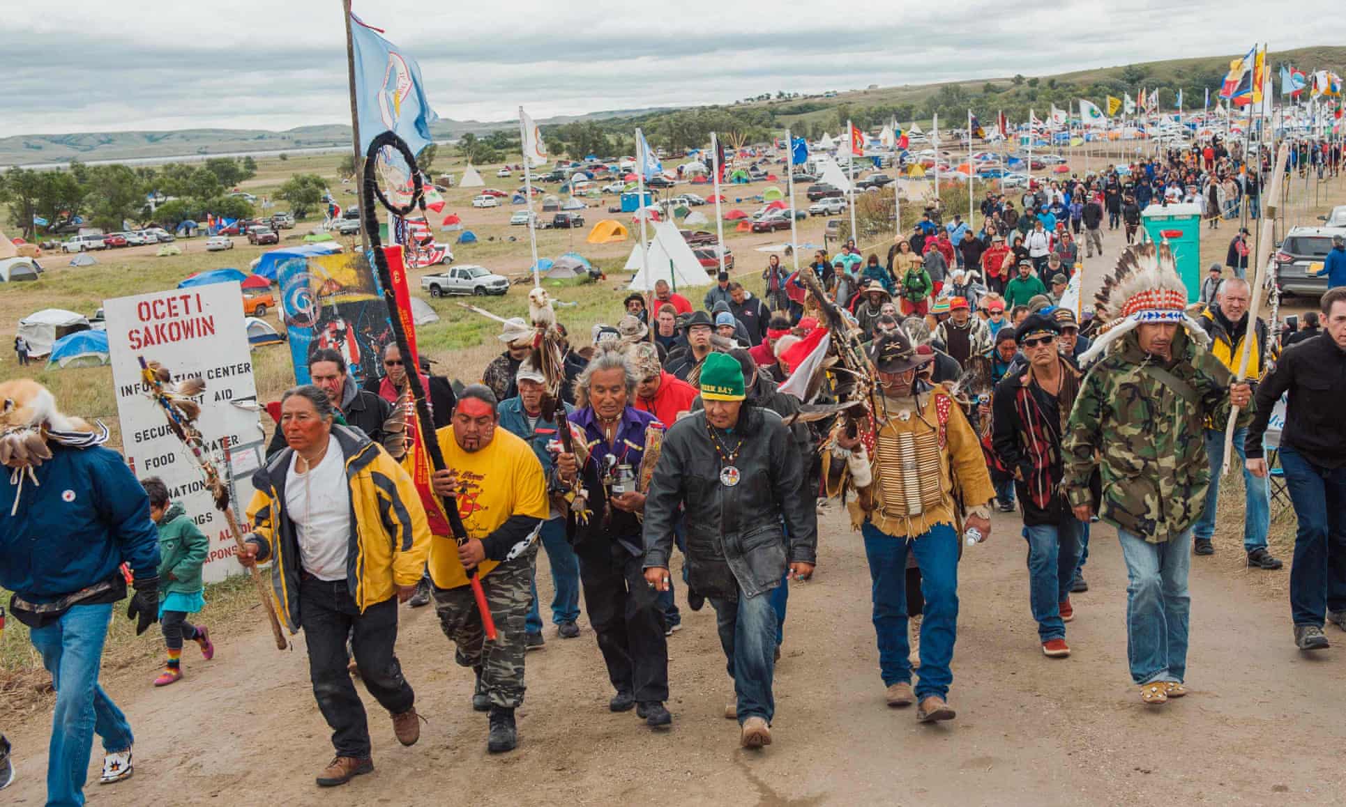
Protests at the Pipeline site in North Dakota began and drew indigenous tribes from throughout North America, as well as many supporters, creating the largest gathering of native tribes in the past 100 years of US history.
“Of the 380 archeological sites that face desecration along the entire pipeline route, from North Dakota to Illinois, 26 of these are right here….
It is a historic trading ground, a place held sacred not only by the Sioux Nations, but also the Arikara, the Mandan and the Northern Cheyenne.
The US government is wiping out our most important cultural and spiritual areas, and as it erases our footprint from the world, it erases us as a people.
These sites must be protected or our world will end.
It is that simple.
Our young people have a right to know who they are.
They have a right to language, to culture, to tradition.
The way they learn these things is through connection to our lands and our history.
If we allow an oil company to dig through and destroy our histories, our ancestors, our hearts and souls as a people, is that not genocide?”
By late September over 300 federally recognised native tribes and an estimated 4,000 pipeline resistance supporters resided at Sacred Stone, with several thousand more on weekends.
Peaceful protests at the pipeline site have continued and have drawn indigenous people from all over North America as well as other supporters.

On 3 September 2016, the South Dakota Access Pipeline brought in a private security firm.
The company used bulldozers containing native graves and burial artifacts.
When unarmed protestors moved near the bulldozers, the guards used pepper spray and guard dogs to protect the site they were told to guard.
Nine days later, a Colonial Pipeline leak spilled over 350,000 gallons of gasoline in Alabama, further fuelling the criticism of the Dakota Access Pipeline.
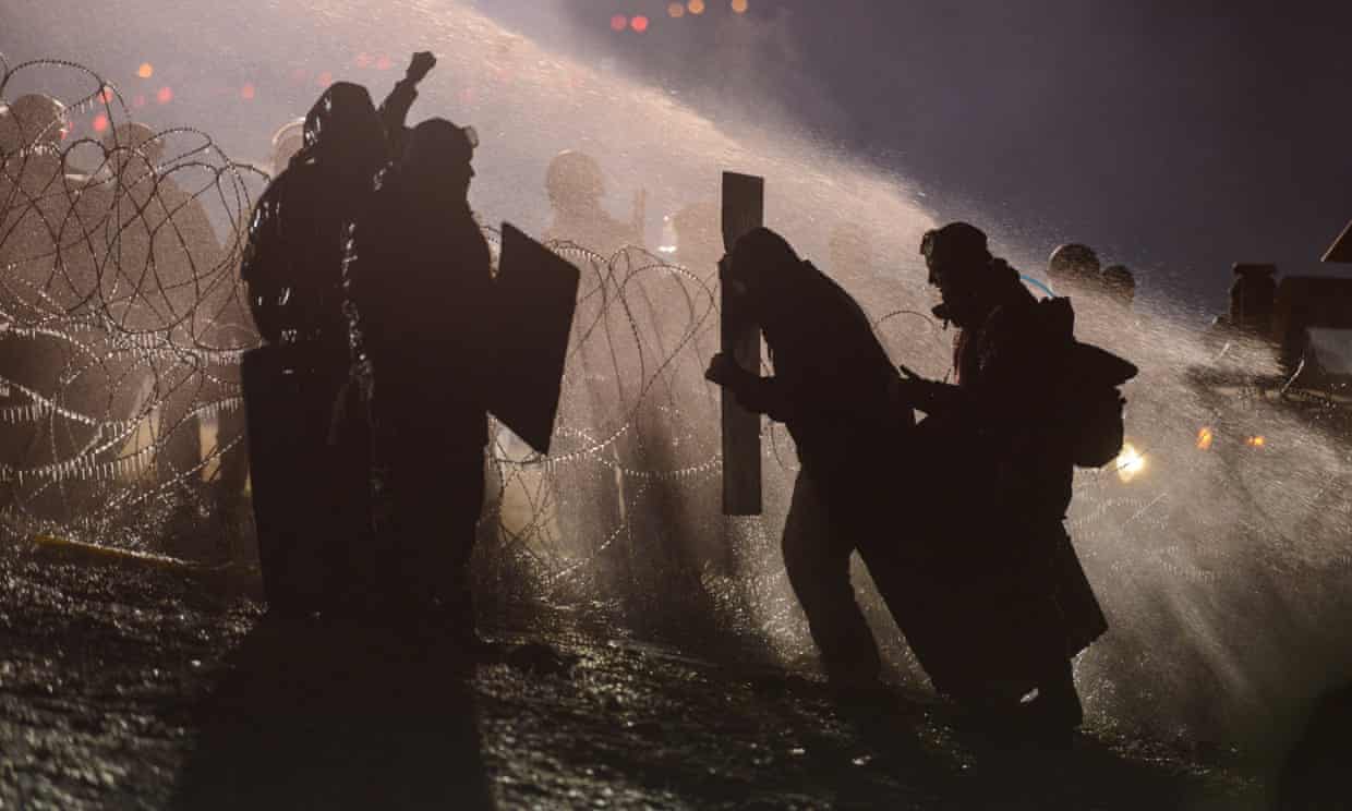
Since my last blog post, (I have been busy.), on the night of 21 November, in -5 degrees Celcius weather, law enforcement officers deployed tear gas and water hoses against hundreds of activists protesting against the Pipeline.

Protestors were also hit with mace, pepper spray, rubber bullets and percussion grenades.
167 people were injured, 7 taken to hospital.
More than 400 activists have been arrested since the protests began.
The unarmed anti-pipeline activists call themselves “water protectors” and they stand unarmed against a highly-militarised police force defending a company that still lacks official permission to drill under the Missouri River.
And chances are strong that the water protectors will lose.

Americans won´t give up their dependance on fossil fuel, regardless of the technology and the capacity to do so that exists.

The US government has historically dishonoured itself by repeated violation of treaties signed with the native tribes and as oil company lobbies pay Congressmen more money than destitute native peoples can, the Pipeline will become yet another betrayal in a long list of betrayals.
Profit remains paramount over people.
And when pipelines break as they inevitably do and clean water becomes scarcer then gold then maybe America will realise the true folly of ignoring the message of Standing Rock.
When America, and the rest of the world, begins to realise that human rights and conservation are intertwined then there is the beginning of hope for the future.
All that there is now is the destruction of the past and the despoilation of the present and the prospect of a depressing future.
Fill ‘er up?
Sources: Wikipedia / The Guardian
